Last week we explored projections, which are they mathematical system used to convert a 3D sphere, like our globe, to a 2D projection, the map. The most commonly used projections are the Mercator, the Gall-Peters and the Albers Conic were all developed in the 18th and 19th centuries, long before the idea of contemporary computing. These mathematicians and cartographers developed the systems that modern day map making rely on. I will spent this weeks post looking at the history of computer mapping.
In the 1960’s a mapping company in Canada first tried to create a digital map that would increase the efficiency and decrease the cost of survey mapping. The company, Spartan Air Services, usually used images taken by an airplane that would later be edited by hand to display the relevant information. Spartan was able to digitize a 5 inch by 5 inch map and show that spatial digitization was possible, so by 1962 they began working with IBM to develop a computer program that was optimized for geologic and geographical programming. Around the same time the Canadian government passed the Agricultural Rehabilitation and Development Act which gave funding to create an inventory for land use and agricultural capability across Canada. Through the production of the Canadian Land Inventory (CLI), a framework for the Geographic Information System, or GIS as it is known today. Below is a video released by the Canadian Forest Service that show the process and implications of digitizing large information.
https://www.nfb.ca/film/data_for_decision/
The early challenges of mapping have paved the way for incredible computing powers that have streamlined the process of cartography and spatial analysis. In 1969, a Harvard professor named Jack Dangermond founded The Environmental Systems Research Institute, or ESRI as it is known today. As it is stated on their website, their early mission was as a “consulting firm [who] applied computer mapping and spatial analysis to help land use planners and land resource managers make informed decisions”. However, by 1981 they had developed a commercial computer software, ARC/INFO that brought computer spatial analysis to a global market. This was the beginning of the computer mapping revolution. Spatial analysis was faster, more affordable, and introduced the idea of computer layering to analyze the world.
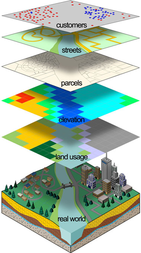
The idea of digital layering is incredibly useful in contemporary mapping as it allows us to break up the real world into several layers that each represent an attribute about the space we are modeling. Being able to analyze different layers help us understand the ways that these attributes interact. These ideas have continued to develop and improve our ability to represent the world in a tangible way. The CLI and ESRI are directly responsible for our ability to pull up a map on our phones, easily avoid traffic using real-time updates, and affordable up-to-date city and land use planning.
Next week we will look at some of the companies that formed and thrived because of the invention of computer mapping, as well as the technologies such as satellites and drones that have helped supplement computerized cartography.
